Environmental Public Health Tracking
New York's Environmental Public Health Tracking (EPHT) Program focuses on tracking environmental and health patterns and trends. Environmental Public Health Tracking is a national program led by the Centers for Disease Control and Prevention. It is intended to improve access to environmental health information and support research, programs and policies that may help protect our communities.
Tracking Data: Environmental Public Health Tracker


Timely Topics
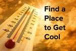
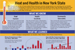
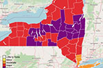
Heat Risk and Illness Dashboard

The new Heat Risk and Illness Dashboard provides a heat risk seven-day forecast, recent heat related emergency department visits and emergency medical service calls and more information by county. This dashboard can be used by emergency planners and public health educators to activate extreme heat operations.
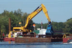
Coastal Beach Water Quality

The Coastal Beach Water Quality Map provides the latest information on water quality monitoring and public notification activities at coastal beaches located along the Great Lakes (Lake Erie and Lake Ontario), Long Island Sound, and the Atlantic Ocean. The map can be promoted to the public so they have the latest information on beach closures and monitoring.
Outdoor Air and Health

As people spend more time outside during the warmer weather, it is important that they understand outdoor air and health. This page provides information on when outdoor air is unhealthy, information on air quality alerts, and recommendations for specific populations.
Tracking Awareness Week

For over 20 years, CDC’s Environmental Public Health Tracking has been used to empower people to understand the connection between health and environment. During Tracking Awareness Week, you can learn about our data, projects, and partnerships and how they empower people to make information-driven decisions that affect their health. Although the future of Tracking is uncertain, public health and public health professionals are resilient! We will continue to grow and adapt to a changing world to continue our mission of connecting people with data!